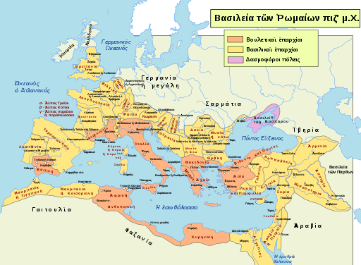
I recently came across a super cool map posted on another blog. It is a map of the Roman Empire during the reign of Trajan (AD 117) when it was at its largest extent. That itself is nothing too noteworthy. There are thousands of those kinds of maps online for any who search. What sets this one apart is that all of the Roman provinces and client states and city names have been translated to reflect their names in Greek! Ancient Greek, to be specific. That is really cool. Wanna see it?

Some info on the map
The map can be found here. It is an SVG file (that’s Scalable Vector Graphic). That is not terribly important to know but it has one really great advantage: the map is resizable to as big or small as you want it without pixelating. To really appreciate it, go and look at it at a larger size. The person responsible for the map is the wikipedia user Furfur. I have no idea what their exact responsibility for the map is. Perhaps they made the .svg file, or did the translation of the map, or both. This user is a far as I can trace the map online.
As mentioned, the map is (most likely) a translation. Here is the map that I presume it is a translation of. This is the same map, only all the names are in Latin.
Is the map in Ancient Greek? While I have not checked every name on it (actually, only a few), they have all been Ancient Greek. Further, I have compared this map to the maps in my Modern Greek Bible and various names on it are markedly different. This leads me to conclude that this map is indeed all in Ancient Greek.
Why it is cool
First, it is Ancient Greek, which makes it cool by default.
Second, one of the great faults in many lexicons is that they don’t deal with names of people and places, or if they do, they have very sporadic coverage. For instance, if you look up βελγική in LSJ–at least the version of LSJ that is freely available–you get nothing. On this map, you clearly see the place and the name. A map like this is a great resource for gaining a general sense of where places are in the Roman world of the time. You can track the main contours of Paul’s travels, for instance, by following the Greek names in the text on this map without any need of transliteration.
Last thoughts
Obviously, this map is merely representative of boarders and spaces. There is a famous debate in NT studies over the exact boundaries of Γαλατία during the time of Paul, for instance, which has implications for reconstructing both his travels and also who the likely target of his polemics is. Neither this map, nor any other static map, will solve such problems or fully reflect the relatively movable boundary lines between different provinces and areas in the day. That being said, this map is super cool and I’m very glad to have come across it. May it help you find your way.
